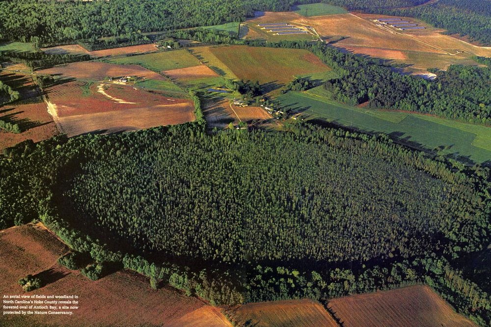
In the 1930s, when the Atlantic coast was being photographed from airplanes for the first time in history, a curious geological feature came to light. The coast stretching from southern New Jersey to northern Florida was littered with thousands of strange elliptical depressions like craters on the Moon. These depressions are now collectively called Carolina Bays, but they are also known by different names. In Maryland, they are called Maryland Basins, and within the Delmarva Peninsula, they are called Delmarva bays. The term “bay” is a reference to the variety of bay trees that grow in and around these depressions.
Carolina Bays are consistently oval in shape and occur in clusters with sizes ranging from a couple to several thousand acres. Most of them are vegetated wetland that fill with rainwater in winter and spring, and dries in the summer months. They share a number of common features, but the most striking of them is their orientation—every single one of them is invariably aligned in the same direction.
Photo credit: Smithsonian
All Carolina Bays display a marked alignment in the northwest to southeast direction, although there are minor local fluctuations. The alignment also deviates systematically by latitude.
Quoting Wikipedia:
The orientation of the long axes of Carolina bays systematically rotate northward along the Atlantic Coastal Plain from northern Georgia to northern Virginia; the average trend of the long axes of Carolina Bays varies from N16°W in east-central Georgia to N22°W in southern South Carolina, N39°W in northern South Carolina, N49°W in North Carolina, and N64°W in Virginia. Within this part of the Atlantic Coastal Plain, the orientation of the long axes of Carolina bays varies by 10 to 15 degrees. If the long axes of these Carolina bays, as measured by Johnson (1942), are projected westward, they converge, neither in the Great Lakes nor Canada, but in the area of southeastern Indiana and southwestern Ohio.
The Wikipedia article has more details about their orientation and deviation, particularly at the northern end of the distribution where “the average orientation of the long axes abruptly shifts by about 112 degrees to N48°E,” and at southern end of their distribution, where the Carolina bays assume “a weak northerly orientation.”
The preference for a particular orientation has led many scientist to believe that Carolina Bays were created when a swarm of meteorites slammed into the Atlantic coast. This hypothesis was much popular in the 1940s and 50s, before earth science had the sophisticated technologies and data analyses that are used today. Modern research have shown that the depressions are too shallow to be impact craters and none of them contain the usual geological evidences of extraterrestrial origin —there are no meteorite fragments, no shatter cones or signs of intense disturbance in the bedrock.
Those who rejects the theory of extraterrestrial origin proposes a number of geomorphological hypotheses including action of sea currents when the area was under the ocean, the upwelling of ground water, or the action of wind. None of these terrestrial formation hypotheses can explain why the bays have elliptical shapes or why they are aligned in the direction they are. The bottom line is nobody can explain them.
It is estimated that were once as many as half a million Carolina Bays along the Atlantic coast, but only a few hundreds have survived or have been preserved. The Woods Bay and Bennett's Bay, in South Carolina, are two examples of protected bays. The majority of them were naturally eroded; others were destroyed by farming, logging, and housing development. During the Second World War, a large bay in Georgetown County was used as a bombing practice range.
Today, these bays are surprisingly rich in biodiversity. Many species of birds, migratory waterfowl, and mammals thrive in these wetlands. Some of them are quite rare or endangered. Other residents include dragonflies, green anoles and green tree frogs. Several carnivorous plants also inhabit Carolina bays.
The original image that started the debate.
The average of the "Long Axis" of multitudes of individual Carolina Bays all converge in certain locations. Image credit: www.georgehoward.net
Photo credit: cosmictusk.com
Photo credit: Cameron Davidson/Getty Images
Photo credit: www.georgehoward.net


A modern version of the impact hypothesis is that the bays are secondary impacts caused by ejecta from an oblique impact on the Laurentide ice sheet. Correcting for the Earth's rotation during long ballistic trajectories resolves the axial convergence to Sabinaw Bay in the great lakes. Lack of material commonly associated with impact events is because the impact was in glacial ice. The bays may actually be from huge ice fragments thrown outward from ground zero, which would have flashed into water and steam when they fell back to earth, leaving large, shallow elliptical depressions.
ReplyDeleteHaving read the book that brought this hypothesis to light I agree it's a very plausible explanation.
DeleteThanks for your two cents! Very interesting idea. It sounds totally plausible to a complete novice.
DeleteMaybe it has something to do with glacier movement, then permafrost melting.
ReplyDelete