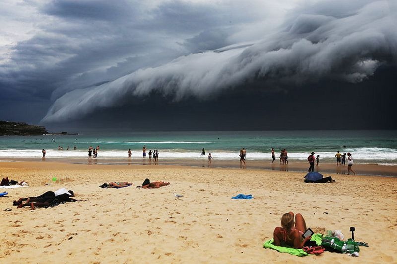
For the last few days, social media is awash with photographs of an extraordinary roll of cloud that has acquired the moniker of “cloud tsunami” hitting the coast of New South Wales, Australia. The ominous cloud measuring several kilometers long that swept across Sydney on Friday last week is actually a shelf cloud.
A shelf cloud is technically an arcus cloud — a kind of low, horizontal, wedge-shaped cloud — that forms at the base of another cloud, usually a thunderstorm cloud, like in this case. When rain from the thunderstorm comes vertically down it drags the air with it, which spreads across the land surface creating a leading edge called a gust front. This outflow cuts under warm air being drawn into the storm's updraft. As the lower cooler air lifts the warm moist air, its water condenses, creating a cloud which often rolls with the different winds above and below. A shelf cloud has a rising motion on the leading edge, while the underside often appears turbulent and wind-torn.
Photo credit: guysebastian/instagram
The Australian Bureau of Meteorology had issued a severe thunderstorm warning as it blew ashore mid-afternoon. Residents were cautioned of large hail, heavy rain, and damaging winds and were asked to stay away from power lines, trees and drains. Local, however, couldn't help but stop to marvel at the spectacular sight.
"People were running from the streets to capture the unbelievable cloud formation," an eyewitness told CNN.
Photo credit: Nick Moir/Twitter
Photo credit: The Telegraph

Photo credit: The Telegraph
Photo credit: Robbi Bishop-Taylor/Twitter
Photo credit: Andrew Jones/Twitter
More examples of shelf cloud
A shelf cloud over Waldhof, Hesse, Germany. Photo credit: Norbert Posselt/Flickr
Photo credit: holgileinchen/Flickr
Shelf cloud moves over Race Point Beach in Cape Cod, Massachusetts. Photo credit: Anthony Quintano/Flickr
Shelf cloud over central Oklahoma. Photo credit: Todd Shoemake/Flickr
A shelf cloud marks the edge of a severe storm near Dundalk, Ontario - back-roads southern Ontario. Photo credit: Dave Sills/Flickr
Views of the shelf clouds that preceded the severe thunderstorms on June 29, 2012, North Aurora, Illinois. Photo credit: Kenneth Cole Schneider/Flickr
Shelf Cloud over South Anastasia Island, 1 August 2013. Photo credit: amy32080/Flickr
Shelf cloud over South Anastasia Island, 1 August 2013. Photo credit: amy32080/Flickr


ominous!
ReplyDelete