On June 6, 1912, after five days of violent earthquakes on the Alaska Peninsula, one of the most gigantic eruptions of the 20th century occurred from a previously unknown geological formation called Novarupta, Latin for “new eruption”. For 60 hours the eruption sent ash and pumice into the sky as high as 30 km and darkened the sky over most of the Northern Hemisphere. As the ejected materials rained down back into the valley it smothered a 100-square km area with ash and pyroclastic flows up to 200 meters deep. Ash fell two feet deep in the neighbouring Kodiak Island 185 km away, and fumes produced acid rains 600 km away, tarnishing brass as far away as California and Colorado. The high-altitude haze robbed the northern temperate zone of an estimated 10 percent of the Sun’s heat during the summer of 1912.
Four years later when National Geographic Society sent Robert F. Griggs for a cover story, he found the valley engulfed in superheated steam escaping from thousands of fissures and cracks. The incredible sight prompted him to name the once vibrant valley “the Valley of Ten Thousand Smokes.”
Photo credit: Robert F. Griggs / National Geographic Society. 1916
Now a hundred years later, most of the fumaroles are extinct and the valley is no longer filled with smoke, but signs of volcanic activity are still visible on nearby hills. The region has been so scarred that in the 1960s it was used in training U.S. astronauts for moon landings. Novarupta itself is a mere bump on the Valley’s floor and rises only 65 meters above its surface. When explorers first entered the Valley, this was one of the hottest areas and the dome still wafts warm steam.
During the eruption a large amount of magma was drained from magma chambers below resulting in the collapse of the summit of another volcano - Mount Katmai, about 10 km away from Novarupta. The collapse produced a crater about two miles in diameter and over 800 feet deep. Early investigators assumed that Katmai was responsible for the eruption. It was not until the 1950s that true source of the eruption was discovered.
Today you can take the trip from Brooks Camp out to the Valley of Ten Thousand Smokes, where the turbulent Ukak River and its tributaries have cut deep gorges in the accumulated ash. The region is still recovering and plants have began to grow on the valley floor. The valley is not yet able to unable to sustain animal life, but moose and bear may cross it from time to time.
Photo credit: Robert F. Griggs / National Geographic Society. 1916
Photo credit: Robert F. Griggs / National Geographic Society. 1916
Photo credit: Robert F. Griggs / National Geographic Society. 1916

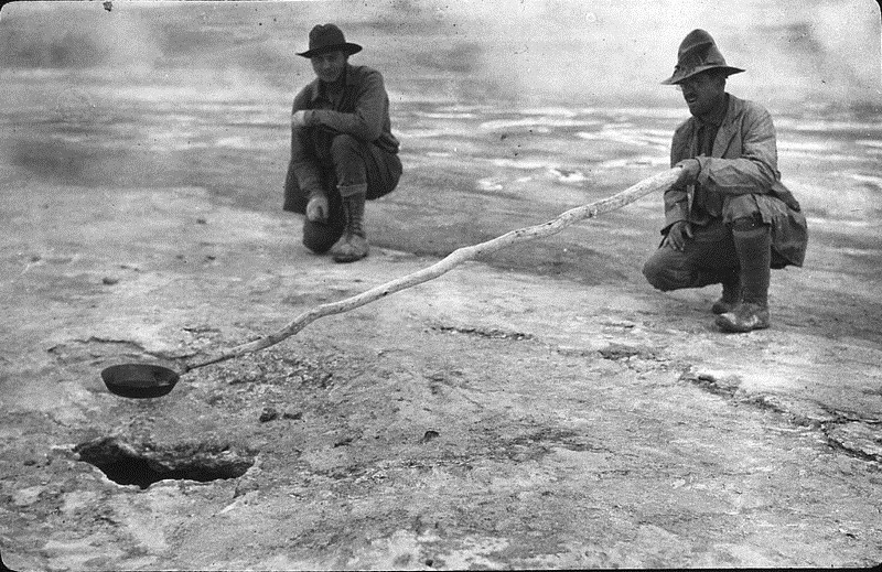
Griggs fry bacon over a hot opening of the Valley of Ten Thousand Smokes, 1916, the National Geographic Society.
The lava dome of Novarupta today. Photo credit
Photo credit: The Alaska Volcano Observatory U.S.
Katmai National Park and Preserve, Alaska. Cross section of the June 1912 ash flow exposed by the River Lethe in the Valley of Ten Thousand Smokes. Photo credit
Sources: NPS / Alaskan Nature / Katmailand / Britannica


Comments
Post a Comment