Between 1405 and 1433, during the Ming era, Chinese Admiral Zheng He, who was also the court eunuch, commanded seven expeditionary voyages as far away as East Africa and Middle East. These expeditions, known in Chinese history as the treasure voyages, consisted of hundreds of ships of enormous dimensions carrying a crew as large as 28,000 and great amounts of treasures. The purpose of the voyages were to project Chinese power and wealth to the outside world, as well as to establish imperial control over the maritime trade.
Zheng He dedicated the last 28 years of his life to marine navigation until he died during or shortly after his seventh and final voyage. When Zheng He returned, China had a new emperor who was uninterested in the continuation of such government-sponsored naval adventures. The Treasure Shipyard in Nanjing, where Zheng He’s massive fleet was built was shut down, abandoned and subsequently lost to history.
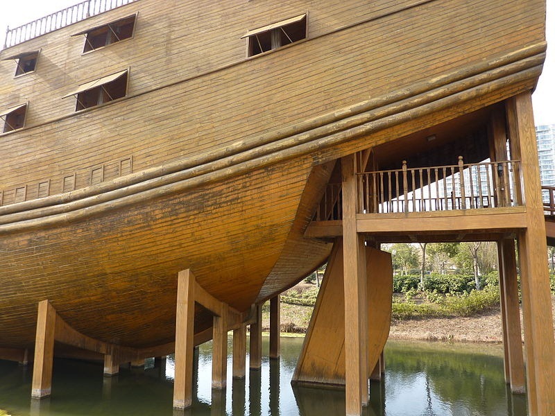
A full-size model of a "middle-sized treasure boat" (63.25 m long) of the Zheng He fleet at the Treasure Boat Shipyard site in Nanjing. Build ca. 2005 from concrete, lined with wooden planks. Photo credit
If recorded accounts are taken as factual, Zheng He's treasure ships were mammoth in size with nine masts and four decks, capable of accommodating more than 500 passengers, as well as a massive amount of cargo. Some of the ships were said to have been 137 meters (450 feet) long and 55 meters (180 feet) wide, which was at least twice as long as the largest European ships of that time. Some sources claim the ships were even longer — 180 meters (600 feet).
Modern scholars argue that Zheng He's ships couldn’t have been that long because wooden ships of such extreme sizes would have pushed the limits of what was possible in wooden ship construction making them unwieldy. There are evidences in later historical periods when ships longer than 100 meters were built, such as HMS Orlando and the schooner Wyoming, and they suffered structural problems. In heavy seas, the ships flexed causing the long planks to twist and buckle. The first ships to attain 126 meters length were 19th century steamers with iron hulls.

The route of the voyages of Zheng He's fleet.
However, scholars agree that the treasure ships were considerably large, some estimating the largest ones to be between 119–124 meters (390–408 feet) in length, while more conservative estimates puts them at about 60–76 meters (200–250 feet).
Compared with other ships, treasure ships were wide in ratio to their length which helped them achieve stability. The hull was V-shaped, the keel long and the ballast heavy. Treasure ships also used floating anchors cast off the sides of the ship in order to increase stability. Watertight compartments were also used to add strength to the treasure ships. The ships also had a balanced rudder which could be raised and lowered, creating additional stability like an extra keel.
In 2005, a Treasure Shipyard park was created in the heart of Nanjing, where several scaled-down replicas of treasures ships are to be found including a full-sized model of one of Zheng He’s smaller vessels.

On the deck of the model Treasure Ship at Nanjing Treasure Boat Shipyard. Photo credit
Inside the stern superstructure of the model Treasure Ship at Nanjing Treasure Boat Shipyard. Photo credit
Inside the model Treasure Ship at Nanjing Treasure Boat Shipyard. Photo credit
Sources: Wikipedia / BSHS Travel Guide


Columbus quelled a mutiny, telling his sailors to press on, that they were not lost, because he knew where he was going.
ReplyDeleteA ship of the Great Fleet had mapped Cuba 70 years before Columbus' voyage. That map, with latitude tables, was given to the Pope-in-Exile by a Chinese ambassador. It was passed on to King Ferdinand and Queen Isabella, who then put out a call for explorers.
Alas, the Great Fleet had been burned, the eunuch admirals beheaded, and the records destroyed by the new Emperor, who despised foreign contamination and a rising middle class. The Great Fleet was near forgotten for centuries.
That
Except of course, the ancient Chinese did not use latitudes, and the maps they made back then were more chronological trip histories scrolling horizontally and didn't actually depict actual north, south, east and west directions, merely the landmarks sighted during the voyage. I doubt very much that a map of Cuba with latitude tables could've been generated by Zheng He given that he could not have known what latitudes was and the maps they drew were hardly accurate portrayals.
ReplyDeleteStill it was an astonishing achievement of Chinese shipbuilding and exploration. The world would have been a different place if the Chinese technology had spread to the west. Makes you think.
ReplyDelete